ThinkAerial
Drone software suite · Live demo

Run a drone data business end to end

Plan and fly, check quality in the field, manage your team, move the data, process it and deliver it to your client. Software we built, and use ourselves, on real projects.

  • Built and used by a working drone company
  • Demo at a time that suits your time zone
  • We set up your account after the demo
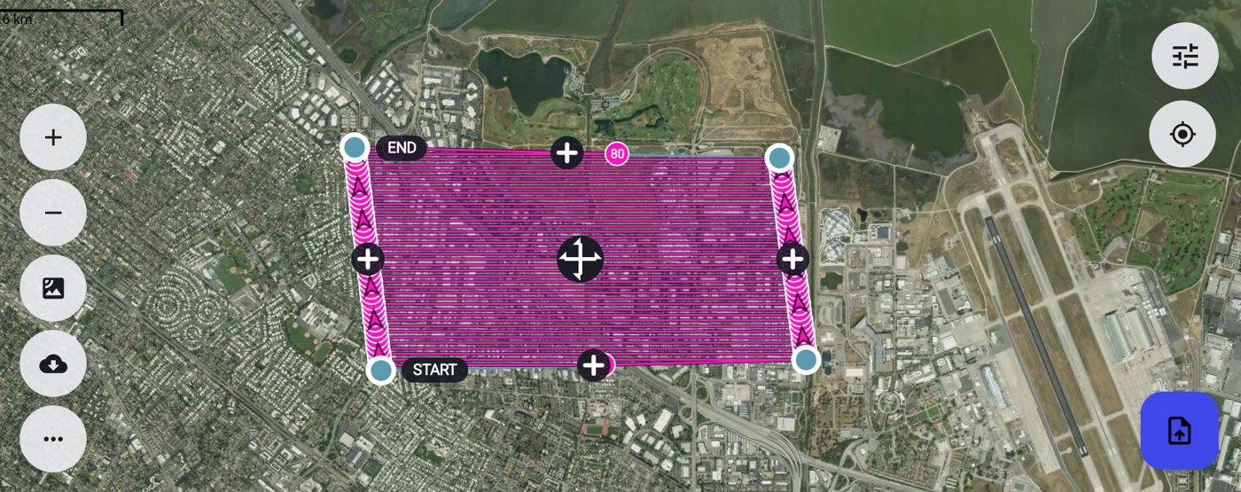
TAFLY mission planner showing a grid survey flight plan drawn over satellite imagery
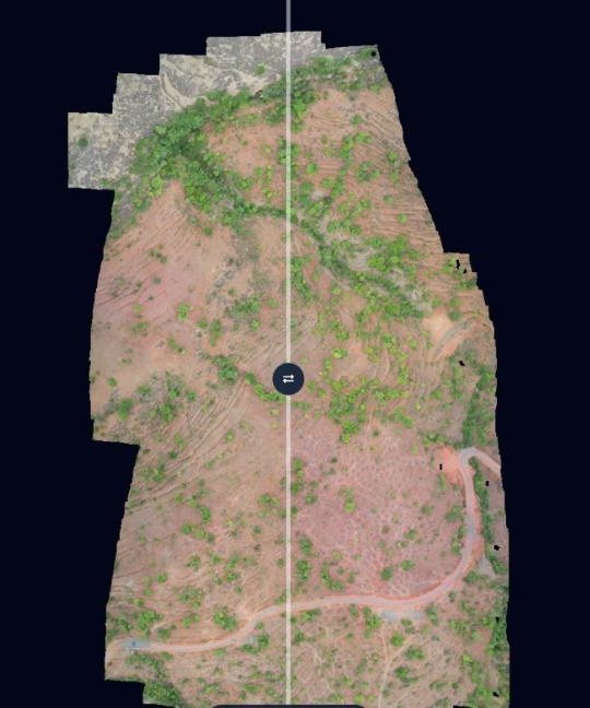
WebGIS map view of a drone orthophoto with measurement and drawing tools
Plan, fly, deliverReal screens from our live apps.

The drone data workflow

  1. Plan & flyTAFLY
  2. Check qualityTAQC
  3. Run the teamPilotReporter
  4. Move the dataTADM
  5. Process · soonTAPROCESS
  6. DeliverWebGIS
  7. Monitor sitesTATL

The products

Each one is shown in a short live demo, so you only see what matters to you.

Live

WebGIS

Give clients a link instead of a folder of files. Drone survey data opens in the browser, ready to measure, compare and inspect.

  • Orthophotos, DSM/DTM, point clouds, 360° and drone video on one map
  • Compare two survey dates; measure distance, area and volume
  • Inspections and solar thermal findings with PDF reports
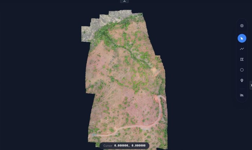
WebGIS map with a drone orthophoto, toolbar and measurement controls
WebGIS compare mode with a swipe slider across a drone orthophoto
Live

TAFLY

A ground control app for ArduPilot and PX4 drones, from mission planning to flight logs, with a web portal for your team.

  • Grid, corridor, waypoint, orbit and 3D capture missions
  • Live pre-flight checklist and a mission simulator
  • Fleet register, flight logs, and KML, QGC and DJI WPML files
  • Tested with SIYI and Skydroid radios on Android devices such as OnePlus tablets
TAFLY grid survey mission drawn over satellite imagery with start and end markers

TAQC

Live

Know the survey flight is good before the pilot leaves site.

  • Checks overlap, GSD, gaps and missing photos against your SOP
  • Daily progress report and a client report PDF
  • Windows app for pilots, web portal for managers

PilotReporter

Live

Projects, flights, equipment and expenses for drone teams, on web and mobile.

  • Flight reports, pre-flight checks, incidents and SOS alerts
  • Equipment and battery tracking, pilot logbook
  • Expense claims, wallets, budgets and invoices

TATL

Live

Timelapse cameras for construction sites, managed from one dashboard.

  • Several cameras per site
  • Camera status, storage and alerts
  • Remote commands from the dashboard

TADM

Live

Move large drone datasets from the field to the office, reliably.

  • Automatic, resumable uploads per project
  • Admins browse and copy data to local drives
  • Notifications, logs and storage analytics

TAPROCESS

Coming soon

ThinkAerial's own photogrammetry suite for survey jobs, in testing now.

  • Planned: orthomosaic, DSM, DTM, contours, point cloud and 3D
  • Planned: thermal, multispectral, LiDAR and inspection workflows
  • Join the list and we will tell you when it opens

How it works

No sign-up forms and no surprises.

  1. Tell us what you doA one-minute survey: your work, team size and drones.
  2. Pick a timeChoose a Google Meet slot that suits your time zone.
  3. See it liveWe show only what is relevant to you and answer your questions.
  4. We set you upIf it fits, we create your account and share pricing.

Book your demo

Answer a few quick questions so we can prepare a demo that fits you. A person from ThinkAerial arranges the call, live when our team is online and within 48 hours otherwise.

About 1 minuteThree short steps, nothing you need to look up.
Live on Google MeetAny time zone. We show your use case, not a generic tour.
Your details stay with usUsed only to arrange your demo. Never shared or sold.

Prefer to talk? Call +91-8097739224.

Request a demo

Step 1 of 3: About you

Which products interest you? (pick any)
Thank you, we have your request.
A person from our team will reply with a time for your demo, live when online and within 48 hours otherwise.
Choose a Google Meet slot (opens in a new tab)

Your answers help us prepare a relevant demo. We never sell or share them.

Questions

Not answered here? Add it to the booking form and we will cover it on the call.

How do I get access?

By demo. Book a call, and we create your account after it. There is no self-sign-up.

What does it cost?

Pricing depends on your team size and how you use the products. We share it after the demo.

Is there a free trial?

We start with a live demo, and what comes after depends on your needs. We will discuss it with you on the call.

How fast will someone reply?

A person from our team replies. It is usually live when someone is online, and always within 48 hours.

Which products are right for me?

Tell us what you do with drone data in the booking form. We will show you only what is relevant.

Do you work with companies outside India?

Yes. We work with teams anywhere, and we arrange the demo at a time that suits your time zone.

Where is my data stored, and is it secure?

We cover storage and security in the demo, so we can answer for your exact needs.

Can you customise it?

Tell us what you need, and our team will discuss it with you after the demo.

See it working on your use case

A short live demo, a clear next step, and no pressure.

Book a live demo